
Source: Meteorologist Brittney Merlot
How does freezing rain and sleet form?
Both freezing rain and sleet form under similar circumstances — when warm air is pushing in on cold.
Jan 6, 2026, 1:34 PM CT
Share
EAU CLAIRE, Wis. (WCFW) – Freezing rain and sleet accumulations can mean treacherous travel this time of year. But how does it form?
Both freezing rain and sleet form under similar circumstances: when a slice of warm air is pushing in above cold air at the surface.
When a cold air mass is sits over Wisconsin with an incoming warm air mass headed in the next day, the two collide. Warm air rises, so as the warm up shoves into the state, it slices above the cold.
Then, there’s a layer of warm air above the cold air. How thick that layer is and where you’re located while the process is underway determines if you’ll get snow, sleet, freezing rain or regular rain.
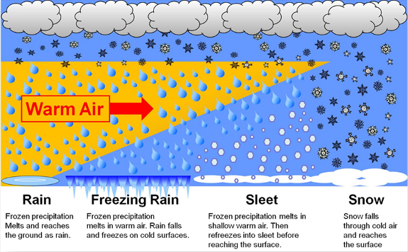
When the entire column of air is below freezing (32 degrees), snow falls. If the temperatures even at high altitudes are all warm and above freezing, raindrops fall.
Freezing rain and sleet depend on how thick the slice of freezing cold air is below.
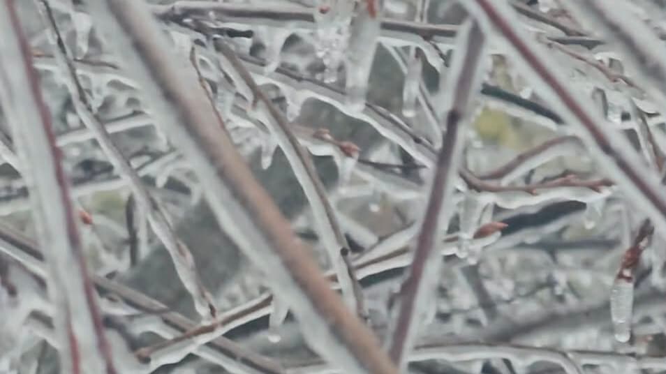
The thicker the layer of warm air above, the better chance it falls as freezing rain. Essentially, a liquid raindrop freezes on contact as it reaches the cold surface temperatures hugging the ground. This creates a coating of ice on whatever the raindrops touch, including cars, handrails, sidewalks and streets.
But if the cold air at ground level extends higher up, then the liquid raindrop has more time to freeze into sleet as it descends to the ground. It’s a frozen raindrop.
Dangers of ice coating
Both freezing rain and sleet are dangerous for driving and even walking around outside. It creates slippery spots and patches of black ice. Bridges, overpasses and ramps ice up faster: as cold air rushes underneath them, they freeze more quickly.
Before you travel, check road conditions in Wisconsin, Minnesota and Michigan. Avoid using cruise control and don’t apply the brakes suddenly, especially on bridges, ramps and intersections.
As ice accumulates on trees and power lines, they become heavy and weighed down. Limbs can snap and power outages becomes common.
Measuring and reporting accumulations
As ice forms on surfaces, it doesn’t accumulate even due to gravity. As liquid falls, you may see one side or area thicker than the rest.
When measuring ice amounts in your area to report to the National Weather Service, follow these tips:
- Measure an ice-covered object that’s out in the open.
- Use a ruler, measure the thickest part of the ice, from the edge of the object to the edge of the ice. Record that value.
- Then, measure the thinnest part of the ice. Record that value.
- Add the two measurements together and then divide by two.
The resulting value is your ice accumulation.
Sleet is measured the same way you measure snow.
- Slide the ruler directly downward until it reaches the ground.
- Read and record the value on the ruler to the nearest tenth of an inch.
You can report freezing rain, sleet, and snow to the National Weather Service by using their storm report form. Include both the time you measured sleet or ice and when it began, along with your location, hazardous road conditions, and any damage liked downed power lines.

Brittney Merlot is Civic Media’s Meteorologist. Email her at brittney.merlot@civicmedia.us.
Want More Local News?
Civic Media
Civic Media Inc.
The Civic Media App
Put us in your pocket.
